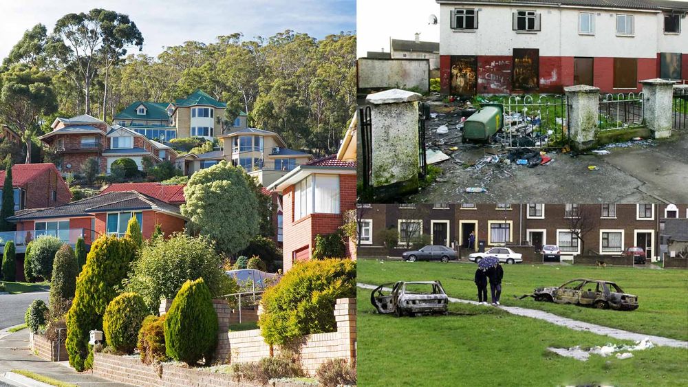
Google Maps is an extremely popular online global maps resource with over a billion monthly users, making it the second-largest digital mapping platform in the world. Google Maps' Street View is a staple in most people's lives, with 67% of smartphone owners using at least once a month. By 2019, Google Street View had captured 170 billion images across 87 counties. Although this tool carries many benefits, such as increased accessibility by providing internet users with easy-to-use street-level navigation tools, and an increased awareness of social inequalities in neighbourhoods, it can also negatively affect social equality by sustaining negative stereotypes (Power, et al., 2012), breaching individual and community privacy (Frome, et al., 2009), and also promote a distorted reality.
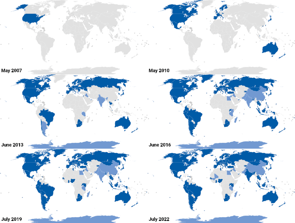
Street View has increased accessibility for billions of people across the globe, providing 360-degree visual representations of streets across 87 countries. Aiding in promoting social fairness and equality by making it easier for people to explore different neighbourhoods and better understand the experience of others. Street View is commonly used for research into a wide range of social equality issues such as public health, architecture, urban design and even neighbourhood biology (Nesse & Airt, 2020). Providing users with a more robust understanding of cultural diversity by giving them a glimpse into different communities. This can assist in breaking down stereotypes and improve knowledge and appreciation of different social groups. On a user level, Street View can equalise the playing field for individuals who may not have access to public transport or the ability to navigate unfamiliar areas independently. Allowing them to plan routes, 'pit-stops', and even locate specific establishments within a street. Proving particularly important to vulnerable groups, such as those with disabilities (Hara, et al., 2013). However, on the other hand, Street View highlights a digital divide that exists within many communities. Demonstrating that only those with reliable access to the internet can utilise its services, thus decreasing social equality.
Following the topic of increased accessibility, Street View has also improved access to critical data for researchers and officials behind social equality developments. Street View data is a staple in numerous studies regarding social equality topics, such as observation of children's neighbourhoods (Odgers, et al., 2012), mapping street-level greenery and openness (Li, et al., 2017), measuring travel time to access opportunities and services offered by cities and towns (Weiss, et al., 2018), Mapping urban perception and characterising inequalities compared with different cities (Salesses, et al., 2013), as well as supporting the development of vision-based driver assistance systems, such as self-driving capabilities (Salmen, et al., 2012), as well as architecture and urban design (Nesse & Airt, 2020). Increasing accessibility and lowering the cost associated with social equality research allows for more action to be taken (Odgers, et al., 2012), which will always benefit and increase social equality.

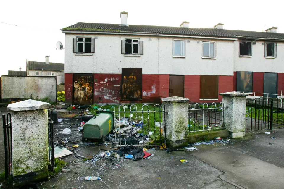
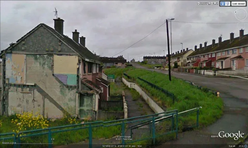
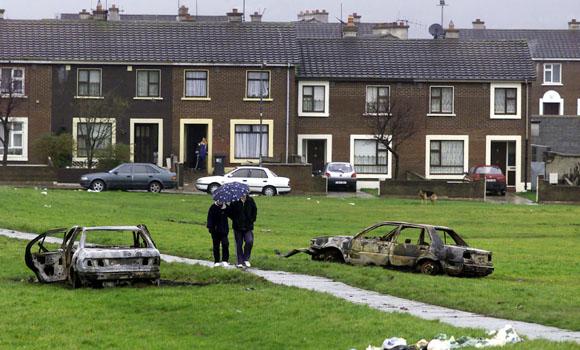
Street View's core business function is making as many streets viewable as possible. Allowing for 'a virtual reflection of the real world to enable armchair exploration'. However, this can be a detriment to many communities by reinforcing negative stereotypes of specific neighbourhoods (Hogler, et al., 1998), which may make it harder for individuals living in these areas to obtain employment opportunities, access education and even dwelling, simply because of existing stereotypes surrounding a neighbourhood or the physical appearance of their house or community (Gorbunova, et al., 2015). This is a very negative consequence of Street View's expansive data set of street images and can significantly isolate individuals and communities. Whether Google intends to or not, this critically limits social equality. It's important to note that this topic is extremely complex, and simply removing Street View from disadvantaged areas will only make social equality worse. Google has been observed excluding locations such as impoverished neighbourhood Moyross, located within Limerick, Ireland. Merely capturing the outskirts, which displayed derelict houses (which no longer existed), desolate spaces, graffitied walls and carless streets. Researchers argue that Moyross was excluded due to social and ideological views of the platform and will have significant and long-term negative impacts on the area, limiting business within the estate and hindering its chances of economic regeneration. One local councillor stated that Moyross was being portrayed as "a Zoo, best viewed from the outside" by Google (Power, et al., 2012).
Street View can additionally open individuals and communities up to significant privacy invasions (Lopez, 2010). Due to its free-to-use nature, Street View can be utilised by anyone as a surveillance tool, invading individuals' privacy. This is especially a concern for vulnerable people within society at greater risk of surveillance and discrimination. Privacy and bias are highlighted on Street View, with data collected potentially being used to discriminate against certain groups or perpetuate biases and stereotypes. Google's position as a commercial organisation is put into the spotlight when viewing certain areas, such as Hidden Hills, California, which completely overrides this aim to capture every street possible—having a zone where Google Street View is unavailable around a location typically home to the rich and famous such as the Kardashians, Pop singer The Weekend, Miley Cyrus and many more. It is evident that the exclusion of Hidden Hills from Street View cannot be attributed solely to the fact that it is a gated community, as other gated communities are shown on Street View. This raises the question of whether Google allows celebrities to pay for increased privacy, which would decrease social equality and fairness—suggesting that privacy is a luxury only available to the wealthy or influential.
Based on the evidence presented, Google's Street View positively and negatively impacts social equality and fairness. While it is a beneficial tool with a large user-base, that has increased accessibility of neighbourhood data for users and researchers, there are concerns about its social awareness, privacy, and exclusion of particular communities. Considering these factors, while Street View has advantages, the current state of this service negatively impacts overall social equality and fairness. To improve this, it is recommended that Google works to increase and update content more frequently, involve local communities to improve the platform's cultural sensitivity—better reflecting the world's diverse groups, and increase transparency around privacy and data use.
Reference List
Arnott, K., 2019. Google Street View Dives into the Largest Fringing Coral Reef in the World. [Online]
Available at: https://blog.google/intl/en-au/products/explore-get-answers/diving-ningaloo-with-street-view/
[Accessed 20 03 2023].
Australian Human Rights Commission, 2020. 8 A right to access the Internet. [Online]
Available at: https://humanrights.gov.au/our-work/8-right-access-internet
[Accessed 21 03 2023].
Barnard, A., 2021. Does Google Maps Have a Route Planner? Yes, And Here’s 5 Reasons Why it Sucks. [Online]
Available at: https://getcircuit.com/route-planner/blog/does-google-maps-have-a-route-planner
[Accessed 21 03 2023].
City of Hidden Hills, 2022. About Us - Hidden Hills. [Online]
Available at: https://hiddenhillscity.org/about-us/
[Accessed 20 03 2023].
Eireannsian, U., 2018. [Ghettos of Europe] Moyross, Limerick, Ireland. [Online]
Available at: https://www.reddit.com/r/europe/comments/83zhxi/ghettos_of_europe_moyross_limerick_ireland/
[Accessed 24 03 2023].
Feinman, G., 2023. What Google Street View Can Say About the Quality of Life in Your Neighborhood. [Online]
Available at: https://www.counterpunch.org/2023/03/09/what-google-street-view-can-say-about-the-quality-of-life-in-your-neighborhood/
[Accessed 20 03 2023].
Frome, A. et al., 2009. Large-scale Privacy Protection in Google Street View. Kyoto, Japan, IEEE 12th International Conference on Computer Vision.
GooBing Detroit., 2020. Detroit's urban decay as seen on Google Street View. [Online] Available at: https://www.goobingdetroit.com/ [Accessed 20 03 2023].
Gorbunova, L., Ambrasat, J. & Scheve, C., 2015. Neighborhood Stereotypes and Interpersonal Trust in Social Exchange: An Experimental Study. City & Community, 14(2), pp. 206-225.
Hara, K., Le, V. & Froehlich, J., 2013. Combining crowdsourcing and google street view to identify street-level accessibility problems.. New York, NY, USA, Proceedings of the SIGCHI Conference on Human Factors in Computing Systems.
Hayes, K., 2007. 'Appalling' social issues in Limerick estates. [Online]
Available at: https://www.irishtimes.com/news/appalling-social-issues-in-limerick-estates-1.980054
[Accessed 21 03 2023].
Hoffower, H., 2018. From hiding their mansions on Google Maps to building $500,000 panic rooms, rich people are sparing no expense to keep their lives private and secure. [Online]
Available at: https://www.businessinsider.in/from-hiding-their-mansions-on-google-maps-to-building-500000-panic-rooms-rich-people-are-sparing-no-expense-to-keep-their-lives-private-and-secure/articleshow/66681557.cms
[Accessed 21 03 2023].
Hogler, R., Henle, C. & Bemus, C., 1998. Internet recruiting and employment discrimination: a legal perspective. Human Resource Management Review, 8(2), pp. 149-164.
Ionescu, D., 2022. How Digital Mapping Can Reinforce Inequity. [Online]
Available at: https://www.planetizen.com/news/2022/06/117510-how-digital-mapping-can-reinforce-inequity
[Accessed 21 03 2023].
Liberatore, S., 2016. How did Kim and Kanye disappear from Street View? Mystery as super rich gated communities become 'invisible' on Google service. [Online]
Available at: https://www.dailymail.co.uk/sciencetech/article-3758825/How-Kim-Kanye-disappeared-Street-View-Mystery-super-rich-gated-communities-invisible-Google-s-service.html
[Accessed 21 03 2023].
Li, X., Ratti, C. & Seiferling, I., 2017. Mapping Urban Landscapes Along Streets Using Google Street View. Cambridge, MA, USA, Springer, Cham.
Lopez, B., 2010. Privacy rights in the age of Street View. ACM SIGCAS Computers and Society, 40(4), p. 62–69.
McClendon, B., 2010. Explore the world with Street View, now on all seven continents. [Online]
Available at: https://googleblog.blogspot.com/2010/09/explore-world-with-street-view-now-on.html
[Accessed 21 03 2023].
McTaggart, J. & Google, 2023. Visual portrayal of neighbourhoods on Street View can perpetuate class divide. [Art] (UOW).
Mukherjee, S. & Zalani, C., 2023. 29 Google Maps Statistics: Verified and Updated For 2023. [Online]
Available at: https://www.onthemap.com/blog/google-maps-statistics/
[Accessed 22 03 2023].
Nesse, K. & Airt, L., 2020. Google Street View as a Replacement for In-Person Street Surveys: Meta-Analysis of Findings from Evaluations. Journal of Urban Planning and Development, 146(2), pp. 04020013-1 - 04020013-10.
Odgers, C. et al., 2012. Systematic social observation of children's neighborhoods using Google Street View: a reliable and cost-effective method. Journal of Child Psychology and Psychiatry, 53(10), p. 1009–1017.
O'Donnell, A., 2020. How Criminals Use Google Street View to Case the Joint. [Online]
Available at: https://www.lifewire.com/how-criminals-use-google-maps-street-view-2487485
[Accessed 21 03 2023].
Power, M. et al., 2012. ‘Why bother seeing the world for real?’: Google Street View and the representation of a stigmatised neighbourhood. New Media & Society, 15(7), pp. 1022 - 1040.
Roberg, M., 2019. How to give Google access to gated community for Street View?. [Online]
Available at: https://support.google.com/maps/thread/22491462?hl=en&msgid=23045710
[Accessed 20 03 2023].
Russell, E., 2019. 9 things to know about Google's maps data: Beyond the Map. [Online]
Available at: https://cloud.google.com/blog/products/maps-platform/9-things-know-about-googles-maps-data-beyond-map
[Accessed 20 03 2023].
Salesses, P., Schechtner, K. & Hidalgo, C., 2013. The Collaborative Image of The City: Mapping the Inequality of Urban Perception. PLoS One, 8(7).
Salmen, J., Houben, S. & Schlipsing, M., 2012. Google Street View images support the development of vision-based driver assistance systems. Madrid, Spain, EEE Intelligent Vehicles Symposium.
Samra, C., 2022. Here’s a list of celebrities who live in Calabasas. [Online]
Available at: https://ktla.com/news/local-news/list-of-celebrities-who-live-in-calabasas-kim-kardashian-kanye-west-drake-and-more/
[Accessed 21 03 2023].
Sharma, M., 2022. HERE Maintains the Location Platform Leadership, Ahead of Google, and TomTom in 2021. [Online]
Available at: https://www.counterpointresearch.com/maintains-location-platform-leadership-ahead-google-tomtom/
[Accessed 20 03 2023].
Simion, E., 2022. Google Street View Timelapse. [Online]
Available at: https://en.wikipedia.org/wiki/File:Google_Street_View_timelapse_additions.gif
[Accessed 20 03 2023].
Weiss, D. et al., 2018. A global map of travel time to cities to assess inequalities in accessibility in 2015. Nature, 553(1), pp. 333 - 336.


